GPX Files - Miscellaneous - 8/20/20 version
The gpx files shown below are unfiltered. Different GPS receivers have differing file length requirements, so I leave the filtering up to those who need it. The files are actual ridden tracks (with a few hand drawn road sections that I will eventually ride). There is usually no elevation info.
| File name (click to download) | Comments |
| GoldBeltTour.gpx 317KB | Starts at Red Canyon Park, north of Canon City, and loops through Cripple Creek, Victor, and Canon City to end at Red Canyon Park. Follows Shelf Road and Phantom Canyon. DS ride. |
|
RBT.gpx 603KB |
Rainbow Trail - starts at Silver Cr and ends at Promontory Divide. See notes below. |
|
RBTaccess.gpx 234KB |
Access to various points along the Rainbow Trail. Dirt roads. See notes below. |
|
RBTandAccess.gpx 836KB |
The RBT and access tracks combined. |
| RedCanParkToSalida.gpx 26KB | Starts at Red Canyon Park, north of Canon City, and ends at Salida. DS ride. |
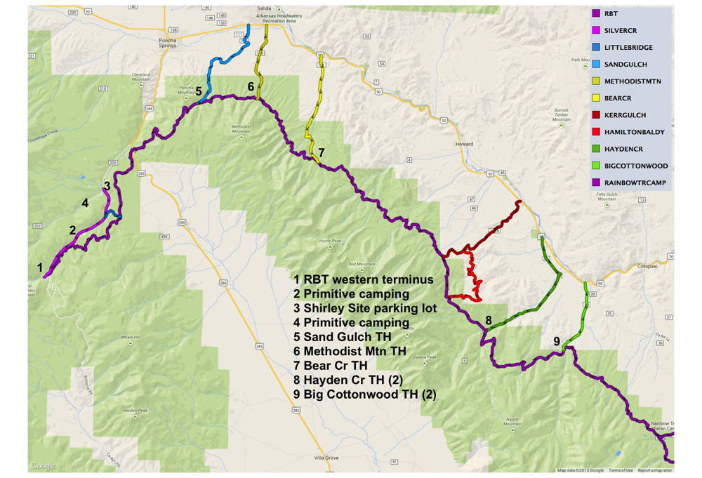
RBT.gpx and RBTaccess.gpx - these files are a pair. RBT.gpx is the Rainbow Trail and RBTaccess.gpx has the routes to the access points along the trail. You can pick a start and end point to suit your time constraints and/or riding ability. Local Salidans like to start at Methodist Mtn and end at Bear Creek for a nice after-work ride.
| Name of access | Road | Track name | Miles |
| Silver Cr Rd | FR201 | SILVERCR | 0 |
| Little Bridge Rd | FR201B/C | LITTLEBRIDGE | 6 |
| Hwy285 | Hwy285 | no track | 10 |
| Sand Gulch | FR124 | SANDGULCH | 16 |
| Methodist Mtn | FR108 | METHODISTMTN | 19 |
| Bear Cr | FR101 | BEARCR | 25 |
| Kerr Gulch | CR45 | KERRGULCH | 36 |
| Hamilton Baldy | CR45 | HAMILTONBALDY | 38 |
| Hayden Cr Rd | FR6 | HAYDENCR | 41 |
| Big Cottonwood | FR40 | BIGCOTTONWOOD | 48 |
| Rainbow Tr Camp | FR198 | RAINBOWTRCAMP | 56 |
| Gibson Cr | FR178 | no track | 70 |
| Hermit Rd | FR160 | no track | 72 |
| Alvarado CG | FR148 | no track | 77 |
| Horn Cr | FR130 | no track | 81 |
| South Colony Rd | FR120 | no track | 89 |
| Grape Cr | FR119 | no track | 95 |
| Promontory Divide | FR412 | no track | 99 |
Good maps
Salida Ranger District MVUM
San Carlos Ranger District MVUM
San Isabel NF visitor map
Trails Illustrated Sangre de Cristo Mountains #138
Some light reading - Bergs Over the Rainbow ADVrider thread